Highway Series Part 9: Route Choice and Redundancy
A freight system shows its weakness the moment its main corridor stops moving.
Every driver knows the feeling. Brake lights stack up ahead. The lane becomes a waiting room. Time drains away one minute at a time. A missed delivery window is harder to fix than extra miles or a slower road. The dock crew may move on to the next appointment. One blocked corridor can damage the rest of the day.
Redundancy protects freight movement. Parallel options let a driver reroute and keep moving. The extra miles may preserve the schedule that matters.
The Single Chokepoint
Early Las Vegas had no parallel options. The railroad set the first line of movement. Fremont Street and Main Street carried more freight weight than their width could handle. Through movement, local delivery, rail access, and commercial activity all pressed into the same small area.
The federal highway designations made the problem precise. By 1940, US 91 entered from the southwest. US 93 entered from the southeast. US 95 entered from the northwest and shared Boulder Highway with US 93 on the way south. All three converged at the intersection of Las Vegas Boulevard and Fremont Street. Every long-haul truck headed to Los Angeles, Salt Lake City, Boulder City, Arizona, or Tonopah passed through the same few blocks of downtown. Every one crossed the Union Pacific tracks at grade. When a train passed, every truck waited.
Wartime Overload
The Second World War tested that single-corridor system to its breaking point. Basic Magnesium Incorporated employed thirteen to fifteen thousand workers at its Henderson plant and produced a quarter of all American magnesium for aircraft engines and incendiary bombs. Every pound of it moved over Boulder Highway. The Las Vegas Army Airfield housed eleven thousand military personnel north of downtown, and all of its supply freight moved up Main Street and Las Vegas Boulevard. Construction materials and aviation fuel for Indian Springs and the Tonopah Test Range moved out the Tonopah Highway after exiting downtown on Bonanza Road.
No bypass was built. The system absorbed the load through congestion. The streets that had been laid out for a railroad town now carried wartime industrial traffic, military supply, and through freight at the same time. They held, but barely, and the strain showed where every US route designation crossed the same intersection.
The First Relief Valves
Boulder Highway had opened in 1931 to support Hoover Dam construction. It gave southeast freight a direct route to Henderson and Boulder City. Built as Nevada's first multi-lane divided highway, it carried US 93, US 95, and US 466 concurrently for decades. A driver bound for the dam, the magnesium plant, or Boulder City no longer had to share the old downtown alignment with northbound traffic to Salt Lake City.
Industrial Road came later, sometime in the late 1950s or early 1960s as the Strip pulled visitor traffic onto Las Vegas Boulevard. It ran north and south parallel to the railroad and the future I-15 alignment, west of the casino frontages. The Strip generated freight at its own tempo. Hotels, casinos, and construction projects pulled in food, linens, equipment, steel, concrete, fixtures, fuel, and service loads. Industrial Road gave that traffic a working corridor and kept it out of the older street pattern.
The valley had begun to develop separate lines for separate kinds of work. Downtown kept its role. The railroad kept its role. The valley was simply no longer asking them to do every job alone. Redundancy rarely arrives all at once. It appears in segments. One new corridor absorbs one old pressure. A second corridor opens another option. Over time the network learns to distribute its own strain.
The Freeway Triangle
Interstate 15 changed the scale. Construction reached the south end of the valley in 1963 and pushed north in stages through the 1960s. The Spaghetti Bowl interchange opened in 1968, elevating the convergence of US 91, US 93, and US 95 from a surface-street intersection to a grade-separated freeway node. By 1971 the freeway ran through downtown. By 1974 the last sections were complete and US 91 was officially decommissioned. Long-haul freight between Los Angeles and Salt Lake City could now stay on the freeway end to end.
The Spaghetti Bowl was the structural turning point. Before it, every directional corridor terminated at the same surface intersection. After it, a truck on I-15 could reach US 95 toward Tonopah without touching a surface street. The chokepoint had become a distribution node.
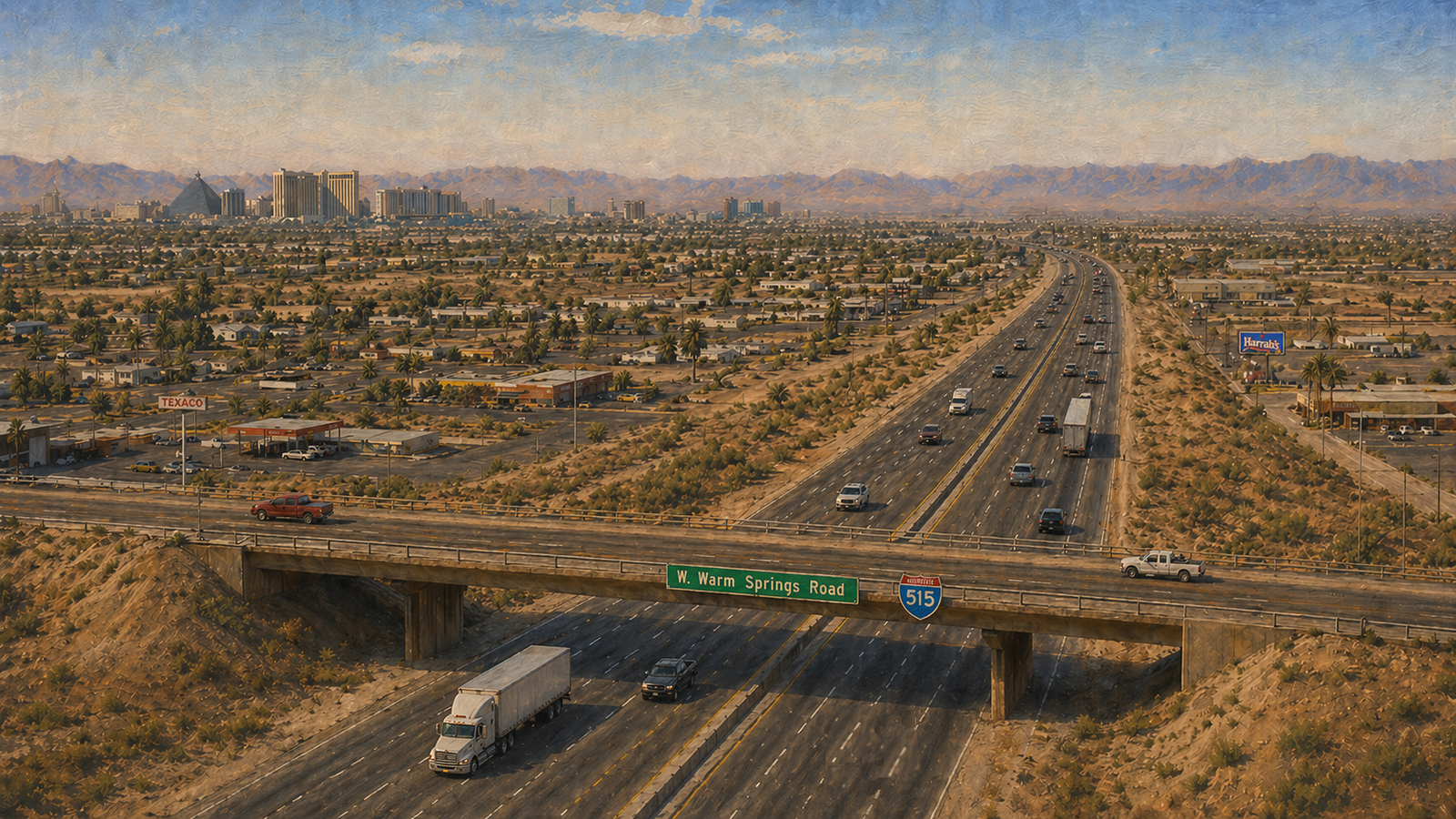
The southeast corridor changed in layers. The US 95 freeway extended west from the Spaghetti Bowl through the late 1970s and was renamed the Oran K. Gragson Expressway in 1982. Construction of I-515 began the same year and reached Henderson in stages, replacing Fremont Street and Boulder Highway as the trunk route. By 1994 I-515 reached Railroad Pass. The valley had its complete freeway triangle. I-15 ran north and south. The Gragson Expressway ran northwest. I-515 ran southeast. All three met at the Spaghetti Bowl. A truck entering from any direction could reach any other on freeway-grade pavement.
Redundancy Under Stress
The value of that network became visible whenever it was tested.
After September 2001, all commercial trucks were banned from crossing Hoover Dam. One to two thousand trucks per day were forced onto a seventy-five mile detour through Laughlin and Bullhead City. The annual cost was estimated at thirty million dollars in delays and fuel. The detour included a six percent downgrade with two escape ramps that Arizona DPS reported being used seventy times a year. The Mike O'Callaghan Pat Tillman Memorial Bridge finally restored the corridor in 2010. The nine years between were a clean demonstration of what happens when a freight corridor has no good alternate.
In September 2014, flash flooding closed fifty miles of I-15 northeast of Las Vegas. Up to five thousand trucks per day were forced onto US 93, a two-lane highway, on a 223 mile detour. The American Transportation Research Institute estimated daily trucking costs at six hundred and seventy thousand dollars. Swift Transportation summarized the situation plainly. This is the wide open West where there are few roads and no reasonable alternative routes. Union Pacific service was also suspended. Track had been undermined near Moapa.
Both events showed the same thing. Even mature networks have limits. The longer a single corridor carries unique traffic, the more painful the moment when something stops it.
Recoverability
In a layered network, disruption imposes a penalty rather than stopping the move. The penalty costs time and fuel. The truck may still make the dock. The driver may still preserve the rest of the day. That is recoverability.
Freight reads a city in turns, delays, clearances, approach angles, queue time, and recovery options. Multiple workable paths matter more than map size or straight-line distance. Las Vegas had become that kind of city. A driver headed south or southeast could think in alternatives. A dispatcher could route around a choke point instead of calling the receiver with bad news.
The goal is to complete the move on time and in sequence. The longer route, the bypass, the road with more miles. Any of them may be the right call if they protect the appointment.
Las Vegas became a place where freight could shift, reroute, and recover. A blocked corridor imposed a penalty. It no longer stopped the move. The distance might grow. The work grew more reliable. What the valley finally built was the power to protect the window.
Sources
The following sources support the historical and operational claims made in this article.
-
The History of the US Route System in Las Vegas, Nevada . Gribblenation. URL
Documents the convergence of US 91, US 93, and US 95 at the intersection of Las Vegas Boulevard and Fremont Street, and traces the surface-street alignments of each route through downtown before the freeway era.
-
Boulder Highway . Planeta. URL
Establishes Boulder Highway as Nevada's first multi-lane divided highway, built in 1931 to support Hoover Dam construction and providing the first southeast freight corridor parallel to the original downtown alignment.
-
Basic Magnesium Inc. . UNLV Special Collections and Archives. URL
Documents the wartime workforce of thirteen to fifteen thousand at the Henderson magnesium plant and the volume of magnesium produced for aircraft engines and incendiary bombs, supporting the wartime overload section.
-
Nellis Air Force Base . The Military Standard. URL
Documents the eleven thousand military personnel stationed at Las Vegas Army Airfield during the Second World War, supporting the wartime overload claim regarding supply traffic moving north through downtown.
-
Spaghetti Bowl (Las Vegas) . Wikipedia. URL
Documents the 1968 completion of the Spaghetti Bowl interchange and its role in elevating the convergence of US 91, US 93, and US 95 from a surface-street intersection to a grade-separated freeway node.
-
Interstate 15 in Nevada . Wikipedia. URL
Provides the construction chronology of I-15 through the Las Vegas Valley from 1960 through 1974, including the decommissioning of US 91 on June 25, 1974.
-
Interstate 515 . Wikipedia. URL
Documents the staged construction of I-515 from 1982 to 1994, replacing Fremont Street and Boulder Highway as the trunk route between downtown Las Vegas and Henderson.
-
U.S. Route 95 in Nevada . Wikipedia. URL
Documents the Oran K. Gragson Expressway and the 1982 relocation of US 95 from its surface-street alignment on Rancho Drive onto the new freeway corridor.
-
Hoover Dam Bypass Bridge: Mike O'Callaghan Pat Tillman Memorial Bridge . American Segmental Bridge Institute. URL
Documents the post-September 2001 commercial truck ban on Hoover Dam, the resulting detour through Laughlin and Bullhead City, the estimated annual cost of thirty million dollars, and the 2010 opening of the bypass bridge.
-
Hoover Dam Detour Causing Problems . Heavy Duty Trucking. URL
Documents the six percent downgrade on the detour route and the use of escape ramps seventy times per year by Arizona Department of Public Safety report, supporting the Hoover Dam truck ban section.
-
Truckers Face Lengthy Detours After Floods Close Stretch of I-15 . Transport Topics. URL
Documents the September 2014 closure of fifty miles of I-15 near Moapa, the resulting 223 mile detour for up to five thousand trucks per day, and Swift Transportation's statement on the absence of reasonable alternative routes.
Leave a Comment
Comments are reviewed before they appear publicly.