Highway Series Part 8: The Urban Network
From Corridor to Grid
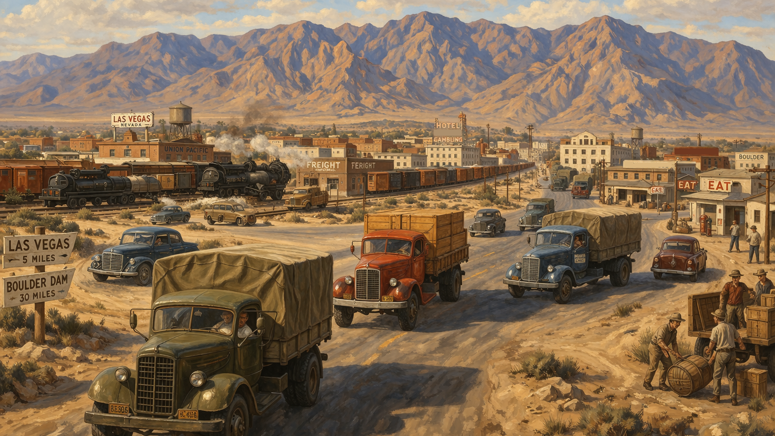
U.S. Route 91 entered the Las Vegas Valley as a single north–south freight corridor. It connected the valley to Los Angeles and Salt Lake City and carried traffic in both directions along one established alignment. As Henderson industrialized and Las Vegas grew, that single line was no longer enough. Freight could enter the valley on the corridor, but distribution across the valley required more connections and more than one path between origin and destination.
The valley built this next layer from streets that already existed. Fremont Street had been the commercial core of Las Vegas since 1905. The street grid had been laid out parallel to the railroad tracks rather than on a true north–south line. Main Street ran along the west side of the tracks. Fifth Street ran along the east side. Fremont Street connected them east to west, with the railroad depot at its western end. The grid had been built for a small railroad town, but it was paved, stable, and already tied to the corridor. Freight trucks moving through Las Vegas used it.
U.S. Route 95 Enters the Valley
U.S. Route 93 already connected Las Vegas to Boulder City and the Colorado River crossing. U.S. Route 95 arrived in 1940. Entering from the northwest along the Tonopah Highway, it moved through Bonanza Road into the downtown grid, continued along Main Street and Fremont Street, and then turned southeast along Boulder Highway toward Henderson and Boulder City. It crossed the same downtown grid at a different angle.
U.S. 95 extended the valley’s reach. It connected Las Vegas to mining districts in central and northwestern Nevada, including Tonopah, Beatty, and Indian Springs, and it ran south toward the California border and Arizona. Those districts had been served by state roads before, but a federal route brought more regular maintenance, clearer signage, and more dependable movement. Las Vegas now sat on two intersecting federal highways.
The Downtown Grid as a Freight Distributor
These routes met inside the existing downtown street grid. Fremont Street carried both designations through part of its length. Main Street ran alongside the Union Pacific rail yard and gave access to freight staging and rail-to-truck transfer that had been active since the dam construction period. The grid met the approaching highways at an angle because it had been laid out parallel to the railroad tracks. Inside it, freight could move from route to route, to the rail yard, and to local destinations without leaving the street network.
The downtown streets worked as a distributor. A truck arriving from Los Angeles on U.S. 91 could reach the rail yard on Main Street, a commercial destination on Fremont Street, or the road east toward Henderson without leaving the grid. The street network linked the two federal routes and gave drivers access to the rail yard and the commercial district in the same pass through downtown. It gave freight more than one way to move between the same points.
Boulder Highway and the Henderson Connection
East of downtown, Boulder Highway carried freight toward Henderson and the industrial operations there. After converging in the downtown grid, U.S. Route 93 and U.S. Route 95 shared this alignment southeast toward Railroad Pass and Boulder City. The Basic Magnesium Plant and Henderson’s industrial corridor stood along that road. Boulder Highway gave Henderson a direct surface connection to downtown Las Vegas, the rail yard, and the main north–south corridor.
This mattered because Henderson was generating industrial freight at scale. Chemical production and materials handling required dependable outbound movement. Finished product left the site by truck and moved into rail or highway distribution from there. Boulder Highway carried those loads into the valley network. Las Vegas Boulevard, carrying U.S. 91 south of downtown, connected them to the main north–south corridor. Freight out of Henderson could move toward Los Angeles or Salt Lake City through more than one path.
The Las Vegas Strip and a Parallel Alignment
South of downtown, U.S. Route 91 left Main Street and followed the southward alignment that became Las Vegas Boulevard. It ran through open desert toward the outlying areas near the state line. In the early 1940s, resort development began along this stretch, and the road started carrying passenger traffic and service deliveries alongside through freight. The corridor was now serving both local growth and long-distance movement at the same time.
The valley now had two north–south paths. The downtown grid carried freight through the commercial core. Las Vegas Boulevard carried traffic south of downtown along the same federal corridor. Both alignments served U.S. 91. Drivers could use the grid or the boulevard depending on the load and the destination.
What a Grid Does That a Corridor Cannot
A corridor moves freight along a single line. That works as long as both ends of the trip sit on that line. In a growing valley, they usually do not. Industrial sites, commercial districts, rail yards, and delivery points sit off the main route. Freight needs a way to leave the corridor and reach them.
A grid does that job. It gives freight more than one route to the same destination. If traffic shifts, a turn is blocked, or a new destination appears, the load can still move. Las Vegas acquired that ability piece by piece. Federal routes met inside the downtown grid. Boulder Highway extended the system southeast toward Henderson. Las Vegas Boulevard extended it south toward the state line. Each addition created another usable path through the valley.
The System in Operation
By the mid-1940s, the valley had a working freight network. U.S. Route 91 ran north and south, connecting Las Vegas to Los Angeles and Salt Lake City. U.S. Route 95 linked the city to central Nevada and to routes running south out of the valley. The downtown grid moved freight between those highways and the rail yard on Main Street. Boulder Highway carried industrial traffic to and from Henderson. Las Vegas Boulevard extended the system south through the developing resort corridor.
Each part worked with the rest. A load arriving from Los Angeles on U.S. 91 could reach the rail yard, the downtown commercial district, or Henderson’s industrial corridor in a single pass through the valley. A load leaving Henderson for Tonopah could reach U.S. 95 through the downtown grid. Freight had more than one usable path. That is what made the system a network.
The valley would keep growing, and the network would grow with it. New warehouses, industrial sites, and commercial districts would create new freight demand. New connections would be built to serve them. The structure that allowed that growth was already in place. Federal routes met inside the downtown grid. Boulder Highway reached Henderson. Las Vegas Boulevard extended the system south. The corridor had become a network, and that network would continue to expand.
That growth brought another change. Once the valley had more than one usable path, freight no longer had to follow the same line every time. Drivers and dispatchers could choose between routes based on destination, traffic, and access to the next connection. The network could carry more than movement. It could carry choice. That is the next step in the story.
Sources
The following sources support the historical and operational claims made in this article.
-
Transportation, Streets & Highways Element . City of Las Vegas. URL
Supports the transportation background of Las Vegas: the Union Pacific line paralleling present-day Main Street, Fremont Street as the first paved road and depot approach, U.S. Route 91 as the main Los Angeles–Las Vegas highway, and the broader role of federal highways in the city’s growth.
-
Phase II Huntridge Neighborhood Historic Resource Survey and Inventory . City of Las Vegas. URL
Supports the orientation of Clark’s townsite parallel to the railroad, the early importance of Main, Fifth, and Fremont, the routing of U.S. 91 along Fifth Street and later Las Vegas Boulevard, and the appearance of early Strip resort development along Highway 91 in the 1940s.
-
U.S. 95 and Idaho’s North and South Highway . Federal Highway Administration. URL
Supports the formal extension of U.S. Route 95 through Nevada effective January 1, 1940, placing Las Vegas on a new federal route that linked the valley to mining districts to the northwest and to California to the south.
-
Historical Maps . Nevada Department of Transportation. URL
Provides access to Nevada’s historical state and county highway maps. These maps are useful for tracing the pre-freeway alignment of U.S. 91, U.S. 93, and U.S. 95 through the Las Vegas Valley and for verifying the historic relationship between Fremont Street, Boulder Highway, Rancho/Tonopah Highway, and the downtown grid.
-
Boulder Highway Initiatives . City of Henderson. URL
Supports Boulder Highway’s long role as the surface road connecting downtown Las Vegas, Henderson, and Boulder City. This helps ground the article’s treatment of Boulder Highway as the southeast freight connection between the downtown grid and Henderson’s industrial area.
-
Our History . City of Henderson. URL
Supports the wartime creation of Henderson around the Basic Magnesium Plant and provides context for Henderson as a permanent industrial destination tied to the same corridor system discussed in the article.
-
Las Vegas Depot (Las Vegas, Nev.) . UNLV Special Collections and Archives. URL
Supports the depot as an early and mid-twentieth-century transportation hub and helps anchor the article’s discussion of the rail yard and freight-oriented downtown street pattern along Main Street and Fremont Street.
Leave a Comment
Comments are reviewed before they appear publicly.