Highway Series Part 2: The Wagon Road Across the Desert
From Trail to Road
The corridors across the Mojave Desert did not become roads because someone drew them on a map. They became roads because people kept using them. Several of the desert travel corridors that later shaped the American highway system passed through the Las Vegas Valley. Routes moving north and south between California and Utah crossed the springs there. Other paths connected the valley with the mining districts of central Nevada and the interior West. Long before highways existed, Las Vegas already sat where several important desert roads met. That position would eventually make the valley an important logistics crossroads in the desert Southwest.
Early travelers followed faint trails that mule caravans wore into the desert. Those pack trains carried freight in organized groups. They stopped at reliable springs and moved through the same valleys and mountain passes that earlier travelers already found.
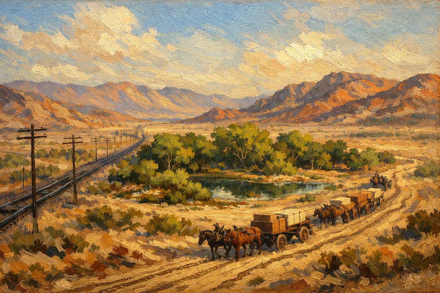
By the middle of the nineteenth century a different kind of traffic moved along the same corridor. Instead of pack animals carrying balanced loads, wagon trains rolled across the desert with freight piled high behind teams of horses or oxen. Wagons required firmer ground and wider paths than mule caravans. Each trip slowly widened the earlier trails.
Movement began to leave a clearer mark on the land.
A single wagon train could carry several tons of freight. The iron-rimmed wheels pressed into the soil with far greater force than the hooves of pack animals. When dozens of wagons followed the same line across the desert valley floor, the surface crust broke down and the trail became easier to see. Later travelers steered their wagons onto the same worn ground rather than forcing a new route through brush and rough terrain.
Over time the faint trail hardened into a recognizable wagon road.
No survey markers announced the change. The road appeared where repeated travel made the desert easier to cross.
Life on the Desert Road
Even as traffic increased, the wagon road across the Mojave remained fragile. Southern Nevada receives little rainfall overall, but several storms usually pass through each year. When they did, sections of the wagon road could change almost overnight. Heavy rain softened the soil along the wagon ruts and turned low ground into thick mud. Loaded freight wagons sometimes stalled in these conditions. Their wheels sank into the softened earth while teams struggled for traction.
Travelers had no way to call for help. Once a wagon train left the last water stop, it faced many miles of desert before reaching the next dependable spring. If a wagon broke down or became stuck in the mud, the drivers had to solve the problem themselves. They might unload cargo to lighten the wagon. Drivers could hitch extra teams to pull it free. In some cases the train waited for the ground to dry.
Storm delays could leave travelers stranded for hours or even days along the desert road. Drivers had to manage water and supplies carefully between stops. The corridor still functioned, but it demanded patience, skill, and careful planning from those who moved freight across it.
The Mormon Road
One of the most important wagon routes through southern Nevada was the Mormon Road.
In the early 1850s, Mormon settlers traveling between Salt Lake City and Southern California began using the corridor regularly. The road connected the growing Mormon communities of Utah with the markets and ports of Los Angeles.
Wagons moving along the route carried a mixture of supplies and freight. Some trains hauled household goods for settlers relocating to new communities. Others carried livestock, grain, tools, and manufactured goods needed in scattered settlements across the interior West.
The Las Vegas Valley became a critical stop along this route for the same reason earlier travelers had used it. The Las Vegas Springs provided dependable water in the middle of a dry desert corridor.
Wagon teams arriving from the north could water their animals, repair equipment, and rest before continuing south toward the Mojave crossing into California. Wagons coming from the coast stopped at the springs before beginning the long climb toward the interior valleys of Utah.
With each season of travel, the corridor grew clearer.
Wagons followed the same approaches to the springs, the same valley floors, and the same passes between mountain ranges. Repeated travel made the desert roads visible.
Military and Supply Routes
Civilian migration was not the only force shaping the wagon corridor across southern Nevada.
During the nineteenth century the United States Army also relied on overland routes through the Mojave to move supplies between frontier posts and settlements. Wagon trains carried equipment, food, and military supplies between California and the interior West.
Army survey parties traveling through the region also used the same corridors that traders and settlers had already established. Their reports documented the locations of springs, the grades of mountain passes, and the distances between reliable water sources. These details helped later travelers plan long desert crossings.
Military traffic reinforced the same routes civilian wagons used.
Supply trains were large. A single expedition could include dozens of wagons carrying provisions for soldiers stationed hundreds of miles apart. When these trains followed the same line across the desert year after year, the wagon road became easier to see and easier to follow.
The corridor became dependable. Travel across the Mojave was still slow and difficult.
Mining Freight and Desert Commerce
Another force shaped the wagon road during the later decades of the nineteenth century: mining.
As mineral districts opened across Nevada, remote camps required a steady flow of supplies. Mining operations needed tools, machinery, timber for underground supports, blasting powder, food for workers, and many other goods hauled across the desert.
Wagon freight carried these materials from railheads and supply towns into the interior mining regions. Some of those routes passed through southern Nevada and used the same desert corridor earlier travelers established.
Wagon trains hauling freight to mining districts often moved in organized groups similar to the caravans of the Old Spanish Trail. Teams hauled heavy loads of machinery and building materials northward through the desert.
A Working Freight Route
Ore from the mines also had to reach processing facilities and markets. Wagons carried mineral concentrates to railheads where the freight continued by train to smelters and industrial centers hundreds of miles away.
Mining traffic strengthened the same desert road that migration and military supply routes had already established.
The corridor had become a working freight route, not just an occasional trail for traders or settlers.
A Recognizable Corridor
By the late nineteenth century the route across southern Nevada was a true overland road.
Travelers approaching the Las Vegas Valley saw the line of the road stretching across the desert floor. Wagon ruts marked the path where thousands of wheels had passed. Vegetation had thinned along the corridor, and disturbed soil showed where earlier traffic broke the desert crust.
Guides and wagon drivers no longer had to rely on memory to navigate the crossing. The road itself pointed the way.
This road lacked many features modern travelers associate with highways. There were no graded surfaces, no bridges, and no engineered drainage. After heavy storms sections of the route could become muddy or difficult to pass. In dry weather the ground hardened again and traffic resumed.
The corridor performed an essential function, connecting settlements, mines, military posts, and trade routes across the desert.
Freight moved along it because there was no practical alternative.
The Road That Would Become a Highway
By the end of the nineteenth century travelers followed well-established routes across southern Nevada.
Mule caravans first marked the corridor across the Mojave. Wagon trains widened the path and strengthened the route between Utah and California. Military supply traffic and mining freight added further use to the same desert road.
Each generation of travelers followed the terrain that geography defined.
When engineers later began planning formal highways across the American Southwest, they did not begin with a blank landscape. They studied routes that had proven workable for decades. Many of the earliest desert highways, like those going into Las Vegas, followed the same valleys and passes mule trains and wagon drivers used long before automobiles arrived.
It began as a faint trail worn by pack animals. Wagon traffic widened it into a recognizable overland road. The next transformation would come when a new machine appeared at the same desert sidings and wagon stops.
Instead of horses pulling freight across the Mojave, motor trucks would begin to do the work.
The corridor itself remained the same.
Sources
The following sources support the historical and operational claims made in this article.
-
Old Spanish National Historic Trail – History and Route . National Park Service. https://www.nps.gov/olsp/learn/historyculture/old-spanish-trail.htm
Describes the mule caravan trade route between New Mexico and California and explains how repeated pack-animal traffic established early desert travel corridors across the Mojave.
-
Las Vegas Mormon Fort Historic Resource Study . National Park Service. https://www.nps.gov/parkhistory/online_books/lame/las_vegas_fort/sec1.htm
Documents the Mormon Road between Salt Lake City and Los Angeles and explains why Las Vegas Springs became a key stopping point for wagon traffic crossing southern Nevada.
-
Transportation and Communication in Southern Nevada, 1865–1905 . University of Nevada, Las Vegas – Digital Scholarship. https://digitalscholarship.unlv.edu/nevada_test_site/vol1/iss1/7/
Describes wagon freight movement, mining supply routes, and the development of transportation corridors across southern Nevada before the arrival of the railroad and modern highways.
-
Las Vegas Springs and Early Travel Routes . Nevada State Museum / Nevada Department of Tourism and Cultural Affairs. https://www.nevadaculture.org/learn/nevada-history/las-vegas-springs
Explains the importance of Las Vegas Springs as a reliable water stop for travelers crossing the Mojave Desert and how multiple wagon routes converged there during the nineteenth century.
Leave a Comment
Comments are reviewed before they appear publicly.