Highway Series Part 1: Mule Paths Through the Mojave
The Terms of the Terrain
Long before survey crews drew highway lines across southern Nevada, travel across the Mojave Desert followed a small number of workable corridors. The desert may appear open on a map, but terrain and water constrain movement across it. Travelers moving between California and the interior West could not choose any direction. They had to follow routes where mountains could be crossed, grades were manageable, and water could be found at predictable intervals.
Animals moving across the desert tended to follow the same valleys and mountain passes as they traveled between seasonal water sources. Springs, seeps, and river crossings served as fixed points in the landscape. Herds moving between these points wore visible paths into the ground. Over time those paths became the easiest ways through the terrain.
The Mojave Desert contains several mountain ranges separated by long valleys. Travel naturally concentrates in the valleys because they offer lower grades and fewer obstacles. Crossing the ranges requires passing through specific gaps where the elevation remains manageable. Once a workable pass is found, travelers returning through the region usually follow the same route again. The terrain quietly directs movement into the same corridors.
Water made the difference between a difficult trip and an impossible one. Reliable springs determined where animals and later human travelers could stop, rest, and continue their journey. Distances between those water sources set the spacing of travel stages across the desert. Routes linking dependable springs and river crossings gradually became the practical paths through the region.
Several of those corridors converged on the Las Vegas Valley. One ran north and south between California and Utah through the Las Vegas Springs. Another connected the valley with the mining districts of central Nevada along the path that later became U.S. 95. A third followed the eastern valleys toward Pioche and Ely, forming the corridor that later became U.S. 93. Together these routes made the Las Vegas Valley a natural meeting point for travel across the desert.
Later travelers followed the same valleys, passes, and springs geography had already defined. The terrain determined where movement concentrated.
Water and Travel
By the time written records appear in southern Nevada, desert corridors were already in regular use by the Southern Paiute and other Indigenous peoples of the region. Their travel routes connected springs, seasonal water sources, and mountain passes across a landscape where water was scarce and distances between reliable sources often determined whether a journey succeeded or failed.
Knowledge of these water sources was not incidental. It formed the foundation of travel across the Mojave. Travelers moving between the Colorado River and the interior valleys of southern Nevada had to know where water could be found and how far it was to the next dependable stop. Springs, seeps, and reliable pools became fixed points in the landscape. Routes linking those points gradually became the practical paths through the desert.
The Las Vegas Springs formed one of those critical locations. Fed by groundwater flowing from the surrounding mountains, the springs provided a dependable water source in a valley that otherwise offered little relief from the desert. For travelers crossing the Mojave, that water made the Las Vegas Valley a natural stopping place. Anyone moving between Colorado River crossings and the passes leading toward Southern California would eventually pass near it.
Indigenous travel routes followed the valleys and passes that allowed movement through the surrounding mountain ranges. The Spring Mountains to the west and the River Mountains to the southeast limited direct travel across the landscape. Crossing these ranges required finding workable passes where grades remained manageable and routes could be repeated safely. Over time those crossings became established parts of the regional travel network.
These routes were practical paths shaped by terrain and maintained through repeated use. Travelers carried knowledge of distances, water sources, and seasonal conditions that made travel across the desert possible.
Caravans
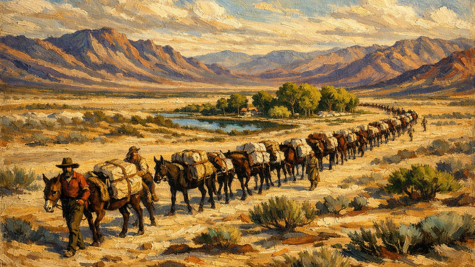
In the early nineteenth century, the corridor began carrying organized trade. Mule caravans on the Old Spanish Trail carried freight between New Mexico and California across the Mojave Desert. The Old Spanish Trail was a network of routes linking trading settlements across the Southwest. Pack trains followed practical desert alignments shaped by reliable water sources, river crossings, and mountain passes.
The trade moved in both directions. Merchants traveling west carried woven wool goods, blankets, and other manufactured items produced in the villages of northern New Mexico. These goods found ready markets in the ranching settlements of California. On the return trip caravans moved east with horses and mules raised in California. Livestock from the coastal ranchos sold at high prices in New Mexico and the interior markets of the Southwest.
The freight moved slowly but in organized groups. Mule caravans often included dozens or even hundreds of animals under the control of experienced traders and guides. Each mule carried packs balanced across its back with goods for trade. The trains moved in stages across the desert from one dependable water source to the next.
Crossing the Mojave required careful planning. Water sources determined where a caravan could stop and how far it could travel in a day. Distances between springs and rivers set the spacing of camps along the route. Travelers who misjudged those distances risked losing animals or cargo before reaching the next water.
One branch of the Old Spanish Trail passed through the Las Vegas Valley because of the reliable water at Las Vegas Springs. In a desert where many streams ran dry during parts of the year, the springs provided a dependable stop for travelers and pack animals. Caravans crossing the Mojave could rest, water their animals, and prepare for the next stage of the journey.
A typical Old Spanish Trail caravan might include dozens, sometimes well over a hundred pack mules in a single train. Each animal placed four iron-hard hooves into the ground with every step.
If a caravan of 100 mules travels one mile, the ground receives thousands of hoof strikes concentrated along a narrow line of travel. Each animal steps forward thousands of times during that distance. The result is repeated impacts along the same strip of ground. When another caravan follows weeks or months later, the animals tend to walk that same line again.
Much of the Mojave Desert is covered by a fragile surface layer known as desert crust. It forms slowly through the compaction of soil particles, salts, and biological material. When intact it can support light travel, but once broken the ground underneath becomes softer and easier to walk on.
Hooves break the crust first. Once the surface is disturbed, animals drift toward the worn path because it offers easier footing than untouched ground. Instead of pushing through brush and crust, they follow the faint line where earlier animals passed.
Caravan guides reinforced this pattern by keeping the train in a tight file. Pack animals traveled nose-to-tail so the line stayed narrow across the valley floor. The goal was control and efficiency. A narrow train is easier to manage than animals scattered across the open desert.
That method concentrated the wear. Instead of light disturbance spread across a wide area, the traffic cut a narrow ribbon where the soil broke and vegetation gradually thinned.
After enough passages, the result became visible. The desert surface began to show a faint track across the basin, shaped by no grading crews and marked by no surveyors. Travelers could see the line where the ground was disturbed, and the route was easier to follow than the untouched desert around it.
That is how many early desert trails formed. Repetition slowly turned movement into geography. The corridor existed first in the memory of the guides, then as a faint path in the earth that later travelers followed across the Mojave.
Once a trail appeared, it quickly became the preferred path. Brush had been pushed aside and the soil loosened, making the line easier to follow than the untouched desert around it.
Undisturbed desert terrain often contains thick brush, uneven ground, and hidden hazards. Moving through it is slower and requires more effort. It can also mean stepping blindly through plants where rattlesnakes or other desert animals may hide.
A worn trail avoids those problems. Earlier traffic has already broken down the brush and the ground is easier to read. Guides can keep the caravan moving without forcing animals through obstacles or risking surprises along the route.
Traders moving freight between California and New Mexico followed the same valleys, passes, and water sources that earlier travelers had already used. What changed in the early nineteenth century was the scale and organization of the traffic. The route had become a working trade corridor across the desert.
Wagon Roads Become Highways
Later travelers used the same corridor. As movement across the region increased during the nineteenth century, wagon traffic followed many of the same paths earlier pack trains had used.
One of the most important of these routes became known as the Mormon Road. Beginning in the 1850s, Mormon settlers and travelers moved between Salt Lake City and the growing settlements of Southern California. The road linked Mormon communities in Utah with Los Angeles and the coastal markets beyond. Wagons carrying supplies, livestock, and household goods traveled south from Utah through southern Nevada and across the Mojave toward California.
The route passed through the Las Vegas Valley because Las Vegas Springs provided one of the few dependable water sources along the way. Wagon trains could stop there to rest animals, refill supplies, and prepare for the next stage of the journey across the desert. Over time the steady flow of travel strengthened the corridor between Utah and California. In the twentieth century that same north–south line became U.S. Route 91, the highway that later carried automobile traffic between Los Angeles, Las Vegas, and Salt Lake City.
Other routes developed for different purposes but followed the same geographic logic. Travelers moving toward Colorado River crossings used paths that gradually defined the corridor that later became U.S. 93. Those crossings connected the interior of Nevada and Utah with Arizona and routes leading farther east.
Mining activity in Nevada also shaped the road network. As mineral districts opened across the state, supply wagons carried equipment, food, and other goods from regional centers such as Las Vegas into the interior. These supply roads connected desert settlements with mining camps and transportation hubs farther north. Repeated use of these routes helped establish the north–south path that later became U.S. 95.
These roads developed gradually as travelers followed workable terrain and dependable water sources. Over time the same corridors that served mule caravans and wagon trains became the foundation of the modern highway network.
By the late nineteenth century the pattern was already established. Old Spanish Trail caravans, Mormon Road wagons, and later military and mining supply routes all used the same practical crossings of the Mojave Desert. Each generation of travelers followed terrain that had already proved workable.
Government surveyors and engineers planning formal highways across the Southwest studied the same valleys, passes, and water stops earlier travelers had relied on. In many places the proposed road simply followed an existing wagon track that had already shown where the land allowed reliable travel.
The corridor between Los Angeles and Salt Lake City was one of the clearest examples. Traders, wagon drivers, settlers, and military expeditions had tested the route for decades. It passed through the Las Vegas Valley because the springs provided dependable water and the surrounding terrain allowed movement between mountain ranges without extreme grades.
Early desert highways gradually formalized that same pathway. Survey crews straightened sections, improved grades, and built bridges where necessary, but the landscape had already chosen the basic line of travel and years of use had reinforced it.
A faint trail worn by mule caravans became a wagon road, then a graded automobile highway, and eventually a widened modern road as traffic increased across the desert corridor.
The modern highway network followed routes already worn across southern Nevada.
Sources
The following sources support the historical and operational claims made in this article.
-
Old Spanish National Historic Trail . National Park Service. https://www.nps.gov/olsp/index.htm
Documents the Old Spanish Trail trade route linking New Mexico and California and explains how mule caravans used desert water sources and established corridors across the Mojave Desert.
-
Las Vegas Springs . Nevada Department of Tourism and Cultural Affairs. https://nevadaculture.org/las-vegas-springs
Describes the historical importance of Las Vegas Springs as a dependable water source used by Indigenous travelers, traders, and wagon traffic crossing the Mojave Desert.
-
U.S. Route 91 History . Federal Highway Administration. https://www.fhwa.dot.gov/infrastructure/us91.cfm
Explains the development of U.S. Route 91 connecting Los Angeles, Las Vegas, and Salt Lake City, illustrating how early wagon corridors evolved into formal highway routes.
-
Mojave Desert . Encyclopaedia Britannica. https://www.britannica.com/place/Mojave-Desert
Provides geographic context for the Mojave Desert, including terrain, mountain ranges, and environmental conditions that shaped travel routes and settlement patterns.
-
The Old Spanish Trail Trade Route . National Park Service. https://www.nps.gov/articles/oldspanishtrail.htm
Details how mule caravans moved goods between New Mexico and California and describes the logistical organization of pack trains traveling across desert corridors.
Leave a Comment
Comments are reviewed before they appear publicly.